The Beginnings of a Colony
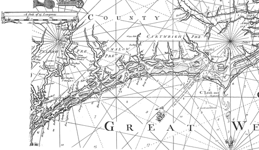
Detail of a 1738 map of Carolina showing various “ferrey” locations along Onslow County’s waterways.
Although Giovanni de Verrazano sailed through Onslow Bay in 1524, Europeans did not attempt settlement along North Carolina's shores until the 1600s. In 1584 an exploratory voyage sponsored by Englishman Sir Walter Raleigh traveled along the coastline of Onslow Bay before establishing Fort Raleigh on Roanoke Island. A map drawn by John White, an artist on the voyage who illustrated the commander's reports, shows remarkable knowledge of the New River area and indicates that Raleigh's explorers may have ventured into the inlet. Both the French and the Spanish attempted settlements along the coasts of the new continent, but their attempts eventually failed. In 1587 the English settlement of Fort Raleigh, initially established in 1585, was re-established on the North Carolina coast, but by 1590 the settlers had abandoned the fort, their fate a mystery. The settlement is historically known as the "Lost Colony."
It was not until the early 1700s that settlement in the coastal region of North Carolina, including present-day Onslow County, was successful. By that time the native Tuscarora Indians were no longer a threat to new settlement; they had either died during the recent Tuscarora War (1711 to 1713), died from newly introduced diseases to which they had no native resistance, or had been forced westward and out of the area. Like the native inhabitants before them, the early European settlers chose the land near navigable waterways for their first homes.
READ MORE (The Early History of Onslow County)
READ MORE (Initial Settlement of Onslow County)
READ MORE (The Early Economy of Onslow County)
READ MORE (Rivers – Transportation, Trade, and Settlement)
Onslow County Is Established
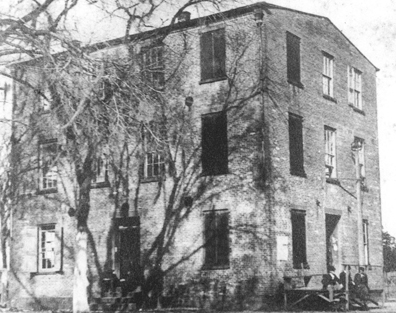
A view of Onslow County’s Courthouse, constructed in 1884. The county seat was moved inland to this location, which was incorporated as Onslow Courthouse in 1785. In 1842, the name of the town was changed to Jacksonville. In 1904, this courthouse was demolished and a new courthouse constructed on this site.
As settlement continued through the early eighteenth century area citizens petitioned Colonial Governor George Burrington requesting that a new precinct, or county, be created to lessen the hardships of dealing with the distant governments of New Hanover and Carteret counties. Governor Burrington responded with an executive order on 23 November 1731, creating Onslow Precinct from portions of Carteret and New Hanover Precincts and naming it in honor of the Right Honorable Arthur Onslow, Speaker of the House of Commons in Great Britain. The General Assembly of the colonial government felt that their prerogatives had been violated, however, and did not recognize the new precinct until 21 February 1734.
Onslow County Courthouses
Onslow County's first three courthouses were located within the Camp Lejeune area. The first courthouse was established in 1732 at Jarrott's Point, from which Courthouse Bay derives its name; the second courthouse was near Paradise Point beginning in 1737; and the construction of the third courthouse was begun at Johnston on Town Point in 1741. In1752, before construction was completed, a catastrophic storm destroyed the partially completed building and reduced the village of Johnston to rubble. Beginning in 1755 all subsequent county courthouses were located at Wantland's Spring, which is known today as Jacksonville.
Slow Growth During the Eighteenth Century
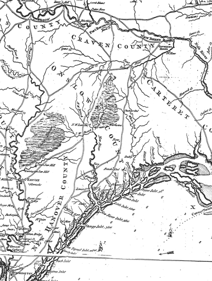
Detail of a 1794 map of the Carolinas indicating locations of large land holdings, small settlements, and ferry crossings along the New River. Major overland routes are also indicated including Old Wilmington Road, which crossed the New River at Sneads Ferry.
Onslow County was a region of mostly small farms whose economy revolved around agriculture, forest products (essentially naval stores), fishing, and rudimentary manufacturing. Naval stores production was based on the extraction of resinous juices from longleaf pines to create tar and pitch, used for waterproofing and preserving the hulls and decks of wooden sailing vessels.
READ MORE (Naval Stores)
READ MORE (The American Revolution in Onslow County)
READ MORE (Population Growth)
Early Statehood
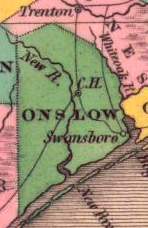
Figure 5. 1824 map of Onslow County (Finley 1824). The location noted as “C.H.” (Court House) later became Jacksonville.
There was little visible change to Onslow County after the American Revolution. The major effect of the war on the county was economic because of the disruption of shipping by the British blockade. Despite the blockade, the coast was kept open and the shallow inlets permitted smaller vessels access to domestic and overseas markets. During the nineteenth century settlement continued further inland along the navigable waterways. Waterways and shipping continued as the primary means of transportation, and naval stores remained the most important export. Naval stores production increased dramatically following the beginning of the French Revolution in 1791 with tar exports more than doubling and turpentine production beginning a rise that would last until the Civil War.
READ MORE (The Great Exodus)
READ MORE (River Navigability Projects)
READ MORE (Antebellum Onslow County)
The Civil War
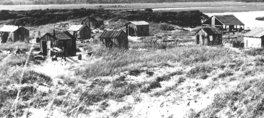
View of the fishing village known as Gilliken’s Island located on the banks of Brown’s Inlet. The fishermen who occupied the seasonal camp lived in these small wooden huts.
The 1860 federal census recorded that of 8,856 people living in Onslow County, 3,499 were slaves. Slaves and free blacks contributed much of the hard labor required to carve the county from the wilderness and the artisans and skilled workmen who produced many of the bridges, boats, and buildings in the county. Of the 1,175 families living in the county, 313 were slaveholders. Thus, approximately 55 to 58 percent of the county's population were either slaves or slaveholders on the eve of the Civil War.
READ MORE (Secession)
READ MORE (Onslow County: The Frontier of the Confederacy)
READ MORE (The Civil War in Onslow County)
READ MORE (Aftermath of the Civil War)
READ MORE (Onslow County Industry and Development in the 1880s)
The Twentieth Century
After almost two centuries, waterborne commerce was supplanted by the railroad during the late nineteenth century. Still, the area's natural waterways, augmented by completion of the Atlantic Intercostal Waterway through the Camp Lejeune area in 1932, remained major arteries of transportation, and many area residents continued to receive their groceries and other supplies by boat from the New River as their ancestors had done for decades. Residents continued to use the network of dirt roads that had existed with minor alteration since the Civil War, but some hard- surfaced roads began to appear. In 1924 U.S. Route 17, which generally follows the trace of the old Colonial Post Road, portions of which passed through the Camp Lejeune area, was completed, and in 1934 State Route 24 was constructed.
READ MORE (Early 20th Century Agriculture and Manufacturing)
READ MORE (1940s Tenant Farms)
READ MORE (Entering World War II)
REFERENCES
Finley, Anthony
1824 North Carolina [Map]. A. Finley, Philadelphia, PA.
Loftfield, Thomas C.
1981 An Archaeological and Historical Reconnaissance of U.S. Marine Corps Base, Camp Lejeune. Submitted to the Department of the Navy, Washington D.C. Ms. on file at the Office of State Archaeology, Raleigh.
Loftfield, Thomas C., and Tucker R. Littleton (compiler)
1981 An Archaeological and Historical Reconnaissance of U.S. Marine Corps Base, Camp Lejeune Part 2: The Historic Record. Submitted to the Department of the Navy, Washington D.C. Ms. on file at the Office of State Archaeology, Raleigh.
The Louis Berger Group
2006 Semper Fidelis: A Brief History of Onslow County, North Carolina, and Marine Corps Base, Camp Lejeune. United States Marine Corps.
Onslow County Historical Society
1983 Heritage of Onslow County. Hunter Publishing Company, Winston-Salem, NC.
Watson, Alan D.
1995 Onslow County: A Brief History. North Carolina Division of Archives and History, Raleigh, NC.