Marines


Surface Danger Zones (SDZ)

Expand List item 13214Collapse List item 13214  SDZ Overview

UPDATE: Click here to view the UXO-31 Public Meeting Video.


To ensure that Marine Corps Base (MCB) Camp Lejeune units are combat ready, certain areas on the Base are used to train military personnel in the use of munitions. For safety purposes, each munitions training range is associated with a safety buffer area, called a surface danger zone (SDZ). More information about SDZs is provided in Background on SDZs.

In 2007, Marine Corps Installations East – MCB Camp Lejeune (MCIEAST - MCB Camp Lejeune) discovered that portions of some SDZs had been located outside the surveyed Base boundary at times dating back to the 1940s. Active range boundaries were adjusted so that the SDZ for each range now lies entirely within the Base boundary. Although there was no indication that a safety risk existed, munitions or munitions-related debris could have previously landed beyond the current boundaries of the Base.  Investigations were conducted in 2010 and 2013 and found munitions and munitions-related items just north of the former target area on Browns Island.

The off-Base SDZ area covers approximately 1,600 acres and is predominantly marshland. Most of this area consists of the SDZ for former Rocket Range Number 1, which has not been used for more than 60 years.  The potentially affected area originally included three private properties totaling approximately 301 acres, as well as the southwestern tip of Bear Island (182 acres of Hammocks Beach State Park), State-owned salt marshes that lie between Bear Island and the mainland, State waters used for fishing and recreation (including portions of Bear Creek), and shallow water areas of the Atlantic Intracoastal Waterway. 

Previous investigations indicate an area of 176 acres between Browns and Sanders Island is the primary location where munitions of concern were found.  In 2014, warning signs were installed around this area, designated as Site UXO-31, to inform the public of the potential explosive dangers present.  Following recommendations of the 2014 Expanded Site Inspection, the current investigations will focus on the reduced 176 acres area.

Expand List item 13216Collapse List item 13216  Background

To ensure that Marine Corps Base Camp Lejeune units are combat ready, certain areas on the Base are used to train military personnel in the use of munitions. For safety purposes, each munitions training range is associated with a safety buffer area, called a surface danger zone (SDZ).

What is a Surface Danger Zone?

An SDZ is an area associated with a training range that is designed to protect people during weapons training. It may include land, water, and airspace. When a range is in active use, the SDZ is an exclusion area that is strictly controlled and could contain projectiles, fragments, or components from firing, launching, or detonating weapons and explosives.

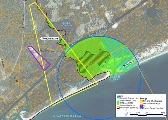
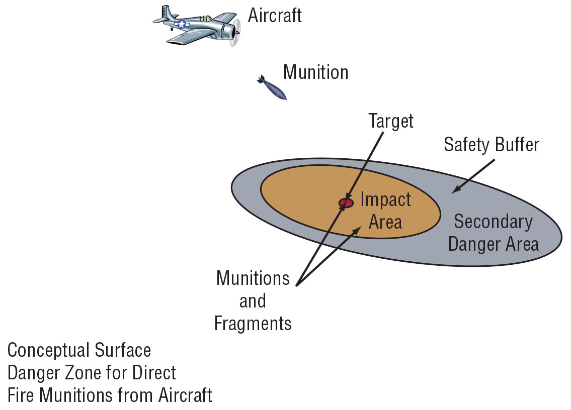
An SDZ is comprised of three parts:

1. Weapons Firing Position: Position from which the munitions are fired.

2. Impact Area: The target or intended area of munitions impact where munitions and munitions fragments are expected to land.

3. Secondary Danger Area: A safety buffer area where fragments from munitions may land.


SDZs are established by Camp Lejeune through Army guidelines and through regulations that are normally associated with public comment periods. The U.S. Army Corps of Engineers’ regulations for public lands and waters are documented in the Code of Federal Regulations (Corps of Engineers, Department of the Army, Part 334 Danger Zones and Restricted Area Regulations, Section 440).

These regulations include safety procedures to ensure that the SDZs are clear of all personnel during training, and that the public is notified when training is conducted. The Department of Defense's current regulations require that SDZs be calculated so that there is only a one-in-one-million chance that munitions or munitions fragments would land outside the secondary danger area.

Identification of Off-Base SDZs

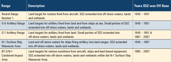
Review and update of Camp Lejeune's Military Installation Map (dated 1996) in 2007 revealed that one current SDZ was depicted as being outside the installation boundary. Specifically, the eastern lateral limit of the SDZ for the G-7 direct fire artillery range (see the table below) was depicted as being on private property near the southeast boundary of the Base. As soon as the issue was identified, the G-7 safety buffer (secondary danger area) was adjusted, so that the entire SDZ now lies within the Base boundary.

Historic range maps and documents were reviewed, and it was determined that some other SDZs were also off the installation. SDZs are continuously updated and examined to reflect changes in training requirements. The SDZs in question were off the Base only during specific time-frames (see the table below), dating back to the 1940s when the Base was established.

After further review of the historic range delineations, it is believed that only portions of the safety buffer areas were located beyond the boundaries of the Base. The boundaries of BT-3/N-1 (see the table and map below) might have been simply an alignment or mapping error and would not reflect actual operations.

Camp Lejeune personnel re-evaluated all ranges on the Base for conflicts with private and State property and are confident that there are no other SDZ's encroaching onto off-Base lands.

However, it is possible that munitions or munitions fragments might have inadvertently landed beyond the boundaries of the Base in the past. Although there has been no indication that a safety risk exists, Camp Lejeune has conducted an investigation to ensure the protection of human safety and health and of the environment.

A chart depicting former SDZs.

Training range SDZ boundaries and affected areas.

A munitions site investigation follows the same basic steps as an investigation of environmental sites under the national “Superfund” program. The first step in such an investigation is called a Site Inspection and is conducted to determine if military munitions or munitions-related debris are present and if there are potential environmental or safety risks.

Initially MCIEAST - MCB Camp Lejeune was leading the investigation, working in partnership with the Naval Facilities Engineering Systems Command Mid-Atlantic, the U.S. Environmental Protection Agency, and the North Carolina Department of Environmental Quality, and in consultation with private property owners and all other interested parties.  As of 2023, Naval Facilities Engineering Systems Command Mid-Atlantic has taken the lead, while we continue to work under the same partnership.

Collapse All Expand All
Expand List item 13217Collapse List item 13217  Former Off-Base SDZs

Investigations Completed to Date

From October 2009 to May 2010, Camp Lejeune conducted an initial site inspection of the former off-Base SDZs.

First, a digital geophysical mapping (DGM) survey – including an aerial survey using helicopters to fly over the entire 1,600-acre investigation area and a terrestrial survey of 27 acres of accessible land –  identified the locations of over 4,000 metallic objects (called “anomalies”).

DGM technology does not distinguish between munitions and other metallic objects that are commonly found in the coastal environment, such as anchors, crab pots, soda cans, pipes, and signs. Therefore, follow-on “intrusive” investigations – digging up selected metallic objects – were conducted, so that munitions experts could determine if they were munitions or munitions debris.

Expand List item 13218Collapse List item 13218  Intrusive Investigation of Bear Island

In November 2010, the Base conducted a combined geophysical survey and intrusive investigation of a 198-acre area on the south end of Bear Island, which is part of Hammocks Beach State Park. This area was the highest priority, because many people visit the park.

An unexpended aircraft flare, which had not fired, was found in a heavily vegetated area. The flare was moved to a disposal pit about 75 feet away and safely destroyed by controlled detonation. Several munitions debris items were found, but none presented an explosive hazard.

Locating and Digging Up Anomalies Aircraft Flare


UPDATE: Summer 2025 survey near Bear Island

A survey of the off-base UXO-31 area was conducted from June 2025 to February 2026.  Certified drone pilots conducted the survey with an unmanned aircraft system (drone) with an attached magnetic sensor to survey the area. 

A public meeting was held on March 26, 2025 to discuss UXO-31 and the recent survey. A link to view the recording of this meeting is at the top of this page.

Additional survey work of the off-base UXO-31 area will continue in April 2026 along with intrusive activities to find and remove possible unexploded ordnance.

For More Information:

The Administrative Record File (a complete record of documents that were used to make investigation and cleanup decisions) and other information about MCB Camp Lejeune’s Environmental Restoration and Munitions Response Programs are available online at:

https://go.usa.gov/xSdBH

If you have questions, please contact the Communications Strategy and Operations Public Affairs Officer at mcieastcommstrat@usmc.mil or (910)-526-2303.

Expand List item 13219Collapse List item 13219  Intrusive Investigation of Remaining Area

From March 2013 through May 2013, MCIEAST - MCB Camp Lejeune completed a follow-on intrusive investigation of selected anomalies in the remainder of the investigation area. During the intrusive investigation, the team used hand-held metal detectors to find each anomaly and then dug it up by hand for identification.

The team dug to a maximum depth of 3 feet below the ground surface. Digging stopped once a hole filled with water, because it became too difficult to see and safely identify the object.


Investigation Results

Six additional munitions items and 79 munitions debris items were found in 2013, primarily in areas that were difficult to access. All the munitions found in the 2013 investigation were near Browns Island, close to the former target area for Rocket Range #1 (see map below).

In the rest of the investigation area, only munitions debris determined to be safe and other common metallic objects (crab pots, boat anchors, beverage cans, and pipes) were found. Most of the munitions debris was found on Sanders Island and in the marsh just north of Browns Island, as shown on the map below.

The munitions items found in 2013 were:

  • Four inert practice items that did not contain explosives (three 2.75-inch rocket warheads and one 5-inch rocket warhead)
  • Two items filled with explosives (one 2.75-inch rocket warhead and one 5-inch rocket warhead)

Munitions items were moved to disposal pits in a remote location and safely destroyed by controlled detonation. Munitions debris, non-explosive items, and other metallic objects were collected and recycled, in accordance with state and federal laws and regulations.

Rocket Warhead Rocket Motor Common Metallic Objects Common Metallic Objects


Expand List item 13220Collapse List item 13220  Installation of Warning Signs

In November 2014, 17 unexploded ordnance (UXO) warning signs were installed along the banks of the waterways within and around the perimeter of the Site UXO-31 area.  The warning signs are posted to inform boaters of the possible risk for munitions identified by the investigation. 

This area has been incorporated into the Brown’s Island Policy. The existing Brown's Island restricted area is outlined in red on the figure below. The Brown’s Island Policy is available here.

Expand List item 13221Collapse List item 13221  Environmental Sampling Results

During the 2010 investigation, the team also collected samples from soil, surface water, groundwater, sediment and pore water (water that is between sediment particles) in the investigation area.

The samples were analyzed for explosives residues, perchlorate (a constituent in rocket propellant), and metals, to evaluate whether contamination related to the former range activities was present.

Explosives residues were not detected in any samples. Perchlorate was detected in groundwater samples at low levels, which were well below the regulatory screening level.

Expand List item 13222Collapse List item 13222  Installation of Warning Signs

In November 2014, 17 unexploded ordnance (UXO) warning signs were installed along the banks of the waterways within and around the perimeter of the Site UXO-31 area.  The warning signs are posted to inform boaters of the possible risk for munitions identified by the investigation. 

This area has been incorporated into the Brown’s Island Policy. The existing Brown's Island restricted area is outlined in red on the figure below. The Brown’s Island Policy is available here.

Expand List item 13223Collapse List item 13223  Site inspection of UXO-31

In 2023, the Preliminary Assessment/Site Inspection (PA/SI) Report for Site UXO-31 was finalized for the smaller 176-acre area where munitions of concern were found.  This report confirmed previous findings and ensured the Site UXO-31 boundary remains valid and that no physical or legal changes to the land or other emergency responses have occurred at the site in the last 10 years.  A remedial investigation was recommended to evaluate UXO presence at Site UXO-31 to confirm the current site boundary is protective.


Conclusions

Based on the intrusive investigation and sampling investigation results, the Base has evaluated potential future hazards. The Expanded Site Investigation Report concluded that:

  • The underwater anomalies that were not intrusively investigated are expected to be like those that were investigated.
  • Buried munitions items are likely to remain in the same locations but could be exposed over time by storms and tides.
  • Because the munitions and related debris were found in areas that are difficult to access, people are not likely to accidentally encounter them. 
  • Given the types of munitions that were found, it is unlikely that casual contact, such as stepping on an item, would cause an explosion. However, such items might explode if they were struck with a rock or tool.
  • Illumination flares from Base training activities may continue to land in areas outside of, but close to, the Base boundaries near active training areas.
  • Based on the results of the environmental sampling, off-Base SDZ activities have not resulted in release of munitions constituents to the environment. There is no unacceptable risk to humans or the environment at the site from exposure to soil, surface water, groundwater, sediment, or pore water.  


Click here to download the "Expanded Site Inspection Report-Off-Base SDZs" Report (May 2014).

For available documents on UXO-31, please visit the following link to access the NAVFAC Administrative Record files:

https://www.navfac.navy.mil/Divisions/Environmental/Products-and-Services/Environmental-Restoration/Mid-Atlantic/Camp-Lejeune-MCB/Administrative-Record/

Search for "UXO 000031” for relevant documentation.

In the U.S. Department of Defense's Munitions Response Program, military installations are encouraged to ask stakeholders for their input in developing relative priorities for investigating munitions sites. Stakeholders include federal agencies, state and local regulatory agencies, tribal governments, landowners directly affected by a site, and interested community members who live or work near the site.

Marine Corps Base Camp Lejeune is committed to informing and involving community members. When the public is actively involved, the investigation/cleanup process is better understood and better cleanup decisions are made.

To keep the public informed and listen to input about the Off-Base SDZs investigation, the Base held a public meeting in 2010 at the Hammocks Beach State Park visitor center. The Base also has mailed several fact sheets about the progress of the investigation to nearby residents.

Restoration Advisory Board

You can learn more about Camp Lejeune's environmental cleanup and munitions response programs by attending meetings of the Restoration Advisory Board (RAB). The best way to get involved in the process is to become an RAB member.

The RAB is made up of community members, along with representatives of federal and state regulatory agencies, Camp Lejeune, and the Navy. The RAB acts as a focal point for exchanging information between the Base and the local community about environmental restoration and munitions response activities.

The RAB meets quarterly at the Coastal Community College, Jacksonville, NC. The date, time, and place of RAB meetings are advertised in the Jacksonville Daily News and the Globe newspapers. The public is always welcome to attend RAB meetings and membership is encouraged.

Click here for additional information on the Camp Lejeune Restoration Advisory Board.


Marine Corps Base Camp Lejeune compiles and makes available to the public a complete record of documents that were used to make investigation and cleanup decisions, called the Administrative Record File. Documents in the Administrative Record File include site work plans, investigation studies, risk assessments, sampling reports, and other materials related to the site.

The Administrative Record File and other information about Camp Lejeune’s Environmental Restoration and Munitions Response Programs is available online at: http://go.usa.gov/Dy5T

Final reports are also available on CDs in the Reference Room at:

Onslow County Public Library
58 Doris Avenue East
Jacksonville, NC 28540
Phone: 910-455-7350

For your convenience, reports and fact sheets about the Off-Base SDZs investigation are available at:

Swansboro Branch Library
1460 West Corbett Avenue
Swansboro, NC 28584
Phone: 910-326-4888

For questions about Marine Corps Base Camp Lejeune, please call 910-451-7645.

Mailing address:
Community Plans and Liaison Officer
Marine Corps Base
PSC Box 20005
Camp Lejeune, NC 28542-0005